This article is a continuation from my previous one on Working at the Meta Level of Design.
In design discussions, I often give the advice: “look beyond the micro and think at the macro level.” It’s an important lens for any serious designer to consider, especially for complex systems and products. While I think it is extremely important, it can stop one layer short of where the most meaningful work actually happens.
Micro to macro is about zoom. Zooming helps you see: a component, a screen, a flow, a journey, an ecosystem.
You’re still looking at the same representation. You’re simply changing how much of it is visible at once. Knowing when to get close and when to step back is a real skill. But zooming has a limit. You can zoom forever and still miss the thing that matters, if you’re looking along the wrong axis.
When Zooming Stops Being Enough
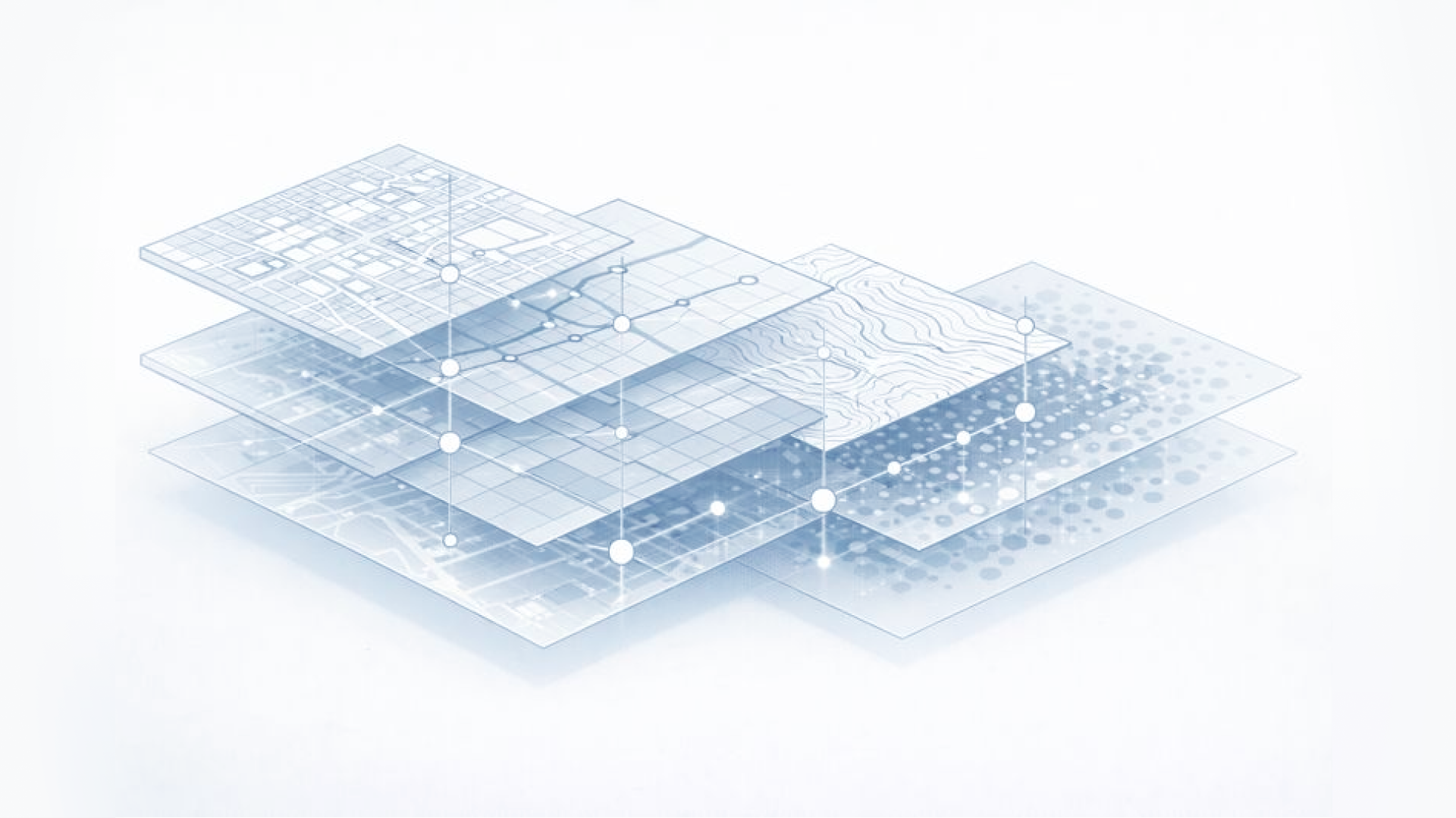
To explain this, we'll use a city metaphor. A city can be represented in many ways:
- A street map
- A subway network map
- A zoning map
- A demographic heatmap
- A topographic elevation map
- A weather map
It’s the same city. But the question changes, and therefore the dimension of the map changes. A street map tells you how to drive. A subway map tells you how to move underground. A zoning map tells you what can be built. A demographic map tells you who is where.
You cannot zoom a street map until it becomes a zoning map. No amount of scale change will transform one representation into another. A shift in dimension is required.
That is where meta-design begins: the recognition that scale is not the only axis. Zoom often changes how much you can see. Dimensions change what you can see.
Where Real Complexity Starts Appearing
Most organisations operate with multiple “maps,” often without realising it. Engineering sees infrastructure. Product sees workflows. Sales sees friction. Support sees failure states. Execs see markets. And design, depending on who you ask, sees UI or systems or journeys. They are all looking at the same city through different maps.
This creates a familiar tension: Everyone is technically right, inside their own dimension. And collectively wrong, because there is no shared logic choosing the right frame.
At a certain level of complexity, zooming out doesn’t help. Zooming out just reveals a bigger mess. The real work is noticing that you are on the wrong map.
The Layer Above Maps
This is where things get interesting. There are design ideas that don’t live inside a single dimension or zoom level. They don’t belong to the street map or the transit system. They don’t only apply at the neighbourhood or regional scale.
They are cross-dimensional logics. They act like an operating system for the city.
Examples in metaphor form: traffic laws, rules of the road, emergency protocols, growth patterns, shared language for classifying situations. These don’t replace maps. They coordinate maps.
They tell you: what kind of moment you are in, what kind of behaviour is required, which maps should activate or fade, and how decisions at street-level connect to regional-level outcomes.
Rush hour is not a street. It is a state. Once you know you are in rush hour, every map behaves differently.
That is the kind of construct that changes everything across micro, macro, and dimension simultaneously.
When a design organisation finds something like that, a unifying logic that explains behaviour across contexts, everything gets easier. Decisions align. Patterns collapse. Work stops fracturing. Future capabilities become possible.
Most teams don’t know what this layer is or how to create it. But once it exists, it becomes impossible to imagine designing without it.
Why This Matters for Senior Work
Early on, designers learn to zoom in with precision and zoom out to see context.
As seniority develops, the work becomes noticing when the representation itself is wrong. Changing dimensions intentionally and introducing shared logics that cut across every map at once. That work often looks abstract...until suddenly it isn’t.
When it’s successful, it:
- Improves the smallest detail
- Clarifies the biggest bet
- Reduces arguments
- Increases coherence
- Makes future design possible instead of expensive
It is meta not because it is theoretical, but because it shapes the conditions under which everything else is done. Zoom tells you how much to see. Dimensions tell you what to see.
Meta-level logic tells you how to think about what you’re seeing.
You start by navigating the city. You end by shaping the language that defines what the city even is.